E-learning
Fundamentals of Spatial Data Acquisition and Mapping
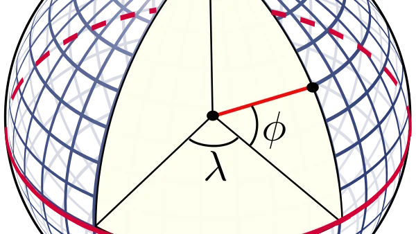
Introduction to Spatial Data and Mapping
Get the foundational knowledge of spatial data and mapping. Find out about the various types of maps, coordinate systems and map projections. Explore the history and evolution of mapping. And familiarise with the methods and technologies used in spatial data acquisition.
Տարածական տվյալների ձեռքբերման և քարտեզագրման հիմունքներ
Ստացեք տարածական տվյալների և քարտեզագրման հիմնարար գիտելիքներ: Իմացեք քարտեզների տարբեր տեսակների, կոորդինատային համակարգերի և քարտեզագրական պրոյեկցիաների մասին: Ուսումնասիրեք քարտեզագրման պատմությունն ու զարգացումը: Եվ ծանոթացեք տարածական տվյալների ձեռքբերման մեջ օգտագործվող մեթոդներին և տեխնոլոգիաներին:
Introduction to GIS and Geo-Visualization
What is GIS, what are the common data formats and tools to start working with spatial data
Learn the basic concepts of GIS and its key components. Work with different types of geodata and understand and apply data models in GIS. Create maps using GIS software, specifically QGIS and web tools and apply cartographic visualization techniques to effectively represent spatial data.
Աշխարհագրական տեղեկատվական համակարգերի և աշխարհագրական վիզուալիզացիայի ներածություն
Սովորեք ԱՏՀ-ի և դրա հիմնական բաղադրիչների հիմնական հասկացությունները: Աշխատեք տարբեր տեսակի աշխարհագրական տվյալների հետ և հասկացեք ու կիրառեք ԱՏՀ-ում տվյալների մոդելները: Ստեղծեք քարտեզներ՝ օգտագործելով ԱՏՀ ծրագրեր, մասնավորապես՝ QGIS և վեբ գործիքներ, և կիրառեք քարտեզագրական վիզուալիզացիայի տեխնիկաներ՝ տարածական տվյալները արդյունավետորեն ներկայացնելու համար:
Advanced GIS
Analyses on spatial data and its use in agriculture
Discover advanced spatial analysis using GIS and utilize and customize various GIS toolboxes for specific tasks. Build and apply GIS models to solve spatial problems. Implement digital tools and apps in precision farming projects. Analyze and interpret sensor data for agricultural applications.
Ընդլայնված Աշխարհագրական տեղեկատվական համակարգ
Բացահայտեք ԱՏՀ-ի միջոցով առաջադեմ տարածական վերլուծությունը և օգտագործեք ու հարմարեցրեք տարբեր ԱՏՀ գործիքակազմեր որոշակի առաջադրանքների համար: Կառուցեք և կիրառեք ԱՏՀ մոդելներ՝ տարածական խնդիրներ լուծելու համար: Ներդրեք թվային գործիքներ և հավելվածներ ճշգրիտ գյուղատնտեսության նախագծերում: Վերլուծեք և մեկնաբանեք սենսորային տվյալները գյուղատնտեսական կիրառությունների համար:
Introduction to Remote Sensing and Earth Observation
The training materials offer a detailed technical foundation for understanding how remote sensing systems work physically and how their data can be evaluated for accuracy and reliability. The concepts of energy conversion by sensors, the importance of resonance, and the statistical nature of information and knowledge are central to this understanding. The detailed explanation of truth evaluation for classifications highlights the practical aspects of assessing the utility of remote sensing data for decision-making.
Հեռահար զոնդավորման և Երկրի դիտարկման ներածություն
Ուսումնական նյութերը մանրամասն տեխնիկական հիմք են առաջարկում՝ հասկանալու համար, թե ինչպես են հեռազգացման համակարգերը ֆիզիկապես աշխատում և ինչպես կարելի է գնահատել դրանց տվյալների ճշգրտությունն ու հուսալիությունը: Սենսորների կողմից էներգիայի փոխակերպման հասկացությունները, ռեզոնանսի կարևորությունը և տեղեկատվության ու գիտելիքների վիճակագրական բնույթը կենտրոնական դեր են խաղում այս հասկացողության մեջ: Դասակարգումների ճշմարտացիության գնահատման մանրամասն բացատրությունը ընդգծում է հեռազգացման տվյալների օգտակարության գնահատման գործնական կողմերը որոշումների կայացման համար:

Advanced Remote Sensing and Earth Observation
The course is designed for vocational training in information extraction from satellite data, with a focus on image classification and segmentation. It covers the fundamental concepts in remote sensing image classification, including the concepts of image and feature space, supervised and unsupervised approaches, various classification algorithms like maximum likelihood, and the crucial step of validating results using error or confusion matrices.
Առաջադեմ հեռազննում և Երկրի դիտարկում
Դասընթացը նախատեսված է արբանյակային տվյալներից տեղեկատվության արդյունահանման մասնագիտական ուսուցման համար՝ կենտրոնանալով պատկերի դասակարգման և սեգմենտացման վրա: Այն ընդգրկում է հեռազննման պատկերի դասակարգման հիմնարար հասկացությունները, ներառյալ պատկերի և առանձնահատկությունների տարածության հասկացությունները, վերահսկվող և չվերահսկվող մոտեցումները, տարբեր դասակարգման ալգորիթմներ, ինչպիսին է առավելագույն հավանականությունը, և սխալի կամ շփոթության մատրիցների միջոցով արդյունքների վավերացման կարևորագույն քայլը:
Satellite Remote Sensing, GIS, and ICT for Precision Farming
This course describes the VETfarm project, an Erasmus+ initiative enhancing pistachio farming in Armenia. It focuses on integrating Remote Sensing, GIS, and ICT for precision agriculture. Key topics include Pistachio Psyllid pest management, technical skill development, and the use of Mobile Labs and Precision Farming Platforms to improve orchard productivity through data-driven geospatial solutions.
Սատելիտային հեռազննություն, ԳԻՍ և ՏՀԶԿ ճշգրիտ գյուղատնտեսության համար
Այս դասընթացը ներկայացնում է VETfarm նախագիծը՝ Erasmus+ նախաձեռնությունը, որը նպատակ ունի բարելավել պիստակագործությունը Հայաստանում։ Այն կենտրոնանում է հեռազննման, աշխարհագրական տեղեկատվական համակարգերի (GIS) և տեղեկատվական և հաղորդակցական տեխնոլոգիաների (ICT) ինտեգրման վրա՝ ճշգրիտ գյուղատնտեսության համար։ Գլխավոր թեմաներն են պիստակի սիլիդի վնասատուների կառավարումը, տեխնիկական հմտությունների զարգացումը և շարժական լաբորատորիաների ու ճշգրիտ գյուղատնտեսության հարթակների կիրառումը տվյալների վրա հիմնված աշխարհագրական լուծումների միջոցով այգիների արտադրողականությունը բարձրացնելու համար։
Planning and Establishment of a Fruit Tree Orchard: An Introduction to Innovative Cultivation Technologies
This course detail modern pomology, emphasizing the use of pure-variety saplings and environmental factors like light and temperature that influence development across nine tree life stages. It outlines critical harvest management, maturity standards, and storage protocols to prevent economic losses. Finally, it advocates for Armenia to adopt intensive, high-density dwarf orchard systems to boost global competitiveness.
Պտղատու ծառերի այգու պլանավորում և հիմնում. Ներածություն նորարարական մշակման տեխնոլոգիաներին
Այս դասընթացը մանրամասն ներկայացնում է ժամանակակից պոմոլոգիան՝ շեշտը դնելով մաքուր սորտի տնկիների օգտագործման և լույսի ու ջերմաստիճանի նման շրջակա միջավայրի գործոնների վրա, որոնք ազդում են ծառի զարգացման ինը կյանքի փուլերի վրա։ Այն ներկայացնում է բերքահավաքի կառավարման, հասունության չափորոշիչների և պահպանման կարևոր պրոտոկոլներ՝ տնտեսական կորուստները կանխելու համար։ Վերջապես, այն առաջարկում է, որ Հայաստանը որդեգրի ինտենսիվ, բարձր խտությամբ թզուկ այգեգործական համակարգեր՝ համաշխարհային մրցունակությունը բարձրացնելու համար։