Map Projections and Coordinate Systems

Reading time
Content
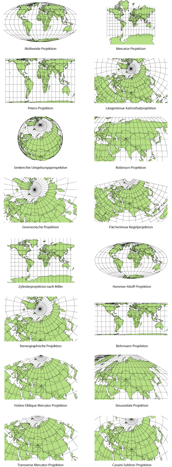
Map projection is a technique used to display the spherical shape of the Earth on a flat surface. It’s a conversion of the 3D shape of Earth to 2D form. There are endless variants of how a map projection can project the earth surface on a plane. Every map projection must grow or diminish some characteristics, including size, shape, distance, direction, and/or scale.
Maps inherently involve distortions because it is impossible to perfectly unfold the surface of a three-dimensional globe onto a two-dimensional plane. When a globe is projected onto a flat surface, some aspects of the map must be distorted, whether it be shape, area, distance, or direction. Different map projections preserve different metrics to suit specific purposes. However, no single projection can preserve all these properties simultaneously, which is why different projections are used depending on the map’s intended purpose.
There are three main groups of projections depending on a property they preserve:
- Conformal projections (like the Mercator projection) preserve angles and shapes locally, making them useful for navigation.
- Equal-area projections (like the Mollweide projection) maintain area accuracy, ensuring that the relative size of regions is correct.
- Equidistant projections (like Plate carée) preserve distances along certain lines.
Beside that, a map projection can be constructed in such a way that none of the above-mentioned properties are preserved, but distortions of all of these are somewhat minified. These are called compromise projections.

Some common map projections / Maximilian Dörrbecker, CC BY-SA 3.0.
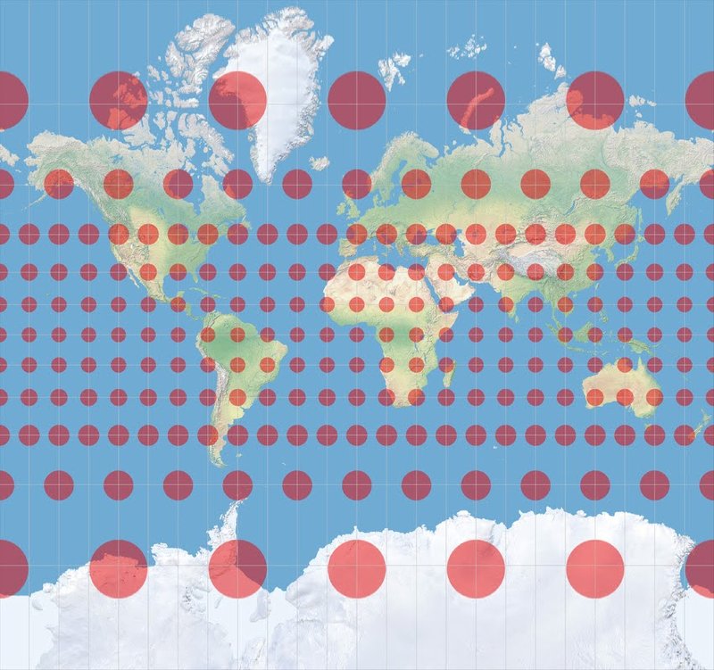
How a certain projection distorts shapes can be observed on a circle with a fixed diameter when drawn on multiple places over the map. Such a circle is called a Tissot indicatrix. Under conformal projections, the tissot’s indicatrix remains circle, but its size is variable across the map. Under equal-area and equidistant projections, the tissot’s indicatrix can be a circle on certain places, but in most places distorts to an ellipsis.

Mercator projection with Tissot’s indicatrix. Source
A coordinate system is a method used to identify the exact position of a point in space using numbers called coordinates. In simple terms, it assigns a set of values (commonly marked as "x", "y" , …) to each point, helping us locate where something is. For example, in a 2D space, the "x" coordinate tells us how far left or right a point is, and the "y" coordinate tells us how close or far away.
A spatial reference system (SRS) or coordinate reference system (CRS) is a framework used to precisely measure locations on the surface of Earth as coordinates. A particular SRS specification comprises a choice of Earth ellipsoid, horizontal datum, map projection, origin point and unit of measure. As possibilities of how an Earth’s surface can be projected to a plane are endless, there are endless ways to define a spatial reference system. Thousands of various SRS have been specified for use around the world or in specific regions and for various purposes. As a consequence, transformations between different SRS are often required.
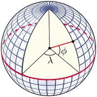
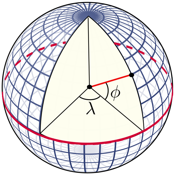
We can divide spatial reference systems into two groups depending on whether they work with geographic (spherical) coordinates or if they work in projected space with cartesian coordinates. A geographic coordinate system represents the Earth as a perfect sphere and any place on the Earth surface can be described by two numbers denoted by greek letters λ and φ. λ is called longitude and φ is called latitude. Longitude and latitude are angles in degrees and can only take on certain values. Longitude values are restricted from -180 to 180, while latitude values are restricted from -90 to 90. In this representation, negative longitude represents the western hemisphere and positive longitude represents the eastern hemisphere. Similarly, negative latitude represents the southern hemisphere and positive latitude represents the northern hemisphere. Alternatively, the hemisphere can be denoted by a big letter after the value like 49° N stands for latitude 49 degrees north or 15° S means latitude 15 degrees south. A point exactly in the cross-section of the main meridian and the equator is on neither hemisphere and its geographic coordinates are [0,0]. This point can be theoretically anywhere, but in the most commonly used geographic coordinate system WGS84, it is in reality inside of an Atlantic ocean, thus it does not point to any special place.
A great circle with a constant longitude is called a meridian. A prime meridian is a meridian with longitude equal to 0. Most widely known is the Greenwich prime meridian, yet others have been in use historically and even nowadays. A great circle with latitude equal to 0 is an equator. Circles parallel to the equator are called parallels or circles of latitude.

Earth as a sphere with meridians and parallels in blue, equator as a red line and latitude and longitude angles in black.
Most commonly used SRS with a geographic coordinate system is WGS84, a realisation of the World Geodetic System standard.
While a geographic coordinate system defines locations on a spherical surface, a cartesian coordinate system (also known as projected coordinate system) represents locations on a flat, two-dimensional surface. The Earth’s surface (or a piece of it) is projected on a plane using one of the map projections. Most common cartesian coordinate systems are based on a Mercator projection, like the UTM (Universal Transverse Mercator) or Web Mercator. Even a Pulkovo 1942 system is a cartesian coordinate system using Gauss-Krüger projection, which is also a variant of Mercator projection.
To identify coordinate systems (both geographic and cartesian), projections and mutual transformation without confusion, a unique database called EPSG exists. It references all common coordinate systems, projections etc. by an “EPSG:” string followed by a numeric code. E.g. WGS84 system has EPSG code EPSG:4326, while Web Mercator has code EPSG:3857 and Pulkovo 1942 has code EPSG:4284. These codes are used to identify coordinate systems in geographic information systems (GIS) but also elsewhere.